
Missouri Ozarks Adventure: Turkey Hunters can Discover Rich History
If there’s a bucket-list destination for Midwestern turkey hunters, it’s the sprawling and rugged hills of Missouri’s Ozark Mountains. These are the hills of my youth, filled with amazing scenery and the chance to experience hunting in its full glory every spring.
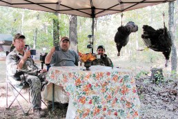
With dogwood trees in full bloom, wild flowers and morel mushrooms popping up all across the hills, America’s leading outdoor communicators return annually to my favorite spots for Spring Turkey Camp. We call it “gathering at the river.” We hunt hard, and field-test hunting products for outdoor magazines, radio, and television.
Let’s relive the spring Turkey Media Camp.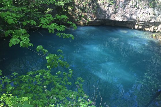
Our first evening on the Big Piney River included sponsor presentations, a hunt orientation, product reviews and a huge dinner catered by Ray Ray’s smoke house barbecue. Our outdoor communicators then broke into two groups, with group one settling in Boiling Springs Campground & Resort to hunt the Big Piney River area.
Our all-women media group traveled south on through blooming Ozark hills and down to Eminence, Mo. We settled in with hosts Jim, the mayor of Eminence, and Jeanie Anderson, at Shady Lane Cabins & Motel. The female hunters are going after turkeys by boat on the beautiful Current River with guide William “Billy River Rat” Smith.
After the morning river hunt and breakfast at a local cafe, Jim Anderson arranged a tour of Alley Mill and the local springs with the park service.
While we were in the Ozarks for a media turkey hunt, there was a wealth of other outdoor recreational opportunities and locations:
Mark Twain National Forest
There is 1.5 million acres of Ozarks forest here with more than 40 campgrounds and picnic sites. Approximately, there are 350 miles of floatable streams, lakes ranging from 10-440 acres and 125 miles of trails for bikers and ATV users. Horseback riding, hunting, hiking (including three national recreation trails), sightseeing and bird watching are other popular activities. Visit fs.usda.gov/mtnf for more information.
Ozark National Scenic Riverways
America’s first scenic riverway preserves 134 miles of the Current and Jack’s Fork rivers. Year-round enjoyment is available, and viewing the scenic beauty is free, except for Round Spring Cave. Go to nps.gov/ozar/index.htm for more information.
You can be among the first to get the latest info on where to go, what to use and how to use it!
Jack’s Fork River
Just a few minutes outside of Mountain View city limits, take Highway 17 north off U.S. 60 to the river access. Camping, picnicking, swimming and hiking are available. Learn more at: nature.mdc.mo.gov/ discover-nature/places/jacks-fork.
Alley Spring and Mill
Built in 1894, this mill is a jewel in the Ozark National Scenic Riverway’s crown. The three-story mill has been transformed into a museum. The spring empties 76 million gallons per day into the Jack’s Fork River, and a mist hangs over the cool, spring-fed lake located in this captivating park. Other attractions include hiking trails, bluffs, a one-room schoolhouse, campgrounds and historic information. Go to nps.gov/ozar/learn/historyculture/alley-mill.htm.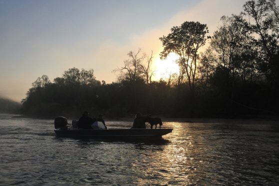
Round Spring
Located on Highway 19 north of Eminence, this spring is one of the most beautiful in the Ozarks. It forms a pool of water that appears to be colored deep aquamarine blue, tinted by the moss growing in and around the spring. A wonderful, heavily decorated cave is open to the public from Memorial Day to Labor Day for two-hour-long tours. A fee is charged for the tour (limited to 15 people). Visit nps.gov/ozar/planyourvisit/round-spring-and-round-spring-cave.htm.
Rocky Falls
This is one of the Ozark’s best-kept secrets even though it’s not hard to find. Water rushed over igneous or lava rock formations colored in deep purple and burgundy. From Winona, take H Highway to NN, then drive two miles on NN to a gravel road marked by a Rocky Falls sign.
Greer Spring
For those who enjoy a challenging hike, this beautiful spring with an average daily flow of 220 million gallons makes it all worth the effort. The well-kept trail includes three wooden footbridges, wildlife and a rock wall that overlooks the spring. It is located in a deep, quiet valley just off scenic Highway 19 between Alton and Winona.
Jam Up Cave
This impressive site is accessible only by canoe on the Upper Jack’s Fork River. From the Blue Springs access, canoe two miles downriver to where the river bends sharply to the left and empties into a deep, wide pool faced by a dolomite cliff that rises more than 100 feet. In the side of the cliff is Jam Up Cave, with an opening 80 feet tall and more than 100 feet across. A waterfall empties into a deep pool in the back of the cave. Leaving Jam Up Cave, the next take-out point is Rymers access from M Highway. Learn more at: nps.gov/ozar/learn/nature/jam-up-cave.htm.
Blue Spring
Located east of Eminence on Highway 106 on the Current River near Owls Bend, is Missouri’s sixth-largest spring, with an average flow of 90 million gallons per day. It is said that Native Americans called this spring “The Spring of the Summer Sky” because of its clear blue color. Visit nature.mdc.mo.gov/discover-nature/places/blue-spring.
Dawt Mill
Built in 1897, Dawt is the only water-powered gristmill located on the North Fork River. The view from the mill overlooking this trophy trout stream cannot be matched. It is now a resort with canoeing, lodging, camping, food and supplies. Come see the restored general store too. Visit dawtmill.com for more information.


Did you enjoy this post?
You can be among the first to get the latest info on where to go, what to use and how to use it!