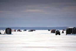
New Views: The Latest Ice Electronics Game Changer?
SHARE THIS POST
To be honest, I’ve grown rather tired of hearing a somewhat overused cliché: Game changer.
However, when it comes to the important role electronics play in modern ice-fishing realms, the term may be appropriate—particularly when considering the increased sophistication of side-imaging—or, to an even greater degree, the development of live-scanning sonar.
Only recently has this concept begun to be better recognized in ice-fishing circles. Those experimenting with such technology agree they’re drilling into yet another cutting-edge facet of ice electronics.
“We hadn’t even gotten our ice display set up yet, and the two Garmin Panoptix machines we had both sold the same day they came in,” said Jesse Francisco of Marine General in Duluth, Minn.
Live scanning brings the underwater world to life
No wonder. Live scanning delivers a lot of benefits. Higher resolution, easier-to-interpret imaging, combinations of GPS mapping and charting capabilities and sonar screens displayed as either a classic flasher face or traditional Liquid Crystal image – each projected in real time. Plus, they offer the capability to present three-dimensional scans extending a hundred feet or more in any direction.
“Given its ability to locate fish at a great distance and see their direction of travel, live-scanning sonar is truly a game changer. Offering a never-before-seen view of the world beneath the ice,” said Troy Roper, an avid ice angler from Pinconning, Mich. “Gone are the days of drilling 50 holes to locate fish. With live scanning, you can search for fish over a vast area with just one hole!”
Troy’s right. This is something special. It’s an advancement you truly must see to appreciate. Some are even saying live-scanning sonar might be the future of ice-fishing electronics.
The pretty penny you’ll have to pay
As is often the case with any newly introduced technology, it doesn’t come cheap. Most serious ice anglers are already investing in GPS mapping technologies to close in on pre-determined locations. Once there, they’re calling upon sonar to determine depth, bottom content, presence of cover, fish, forage, their relative size, depth and position. Then, they’re using underwater cameras to positively identify the exact type of cover and species present. Compared to all that, live-canning technology may not be much of a cost.
Gaining new perspectives
While live-scanning images don’t match the minute details of high-resolution underwater color cameras, they do combine traditional sonar and basic underwater camera functions—along with a few new twists, such as the ability to not only scan from the top down like traditional sonar transducers, but also from the bottom up or sideways, providing new capabilities and perspectives.
If you’re wondering what advantage reading from the bottom up might offer, consider something many traditional sonar users don’t often think about. Traditional, downward-pointing sonar cones are narrowest at the top. Due to this geometric shape, when pointed down in classic fashion, fish suspended high, outside the narrow reach of the upper cone often go unnoticed.
Savvy underwater camera operators have learned to counteract this by positioning their lenses on the bottom, aimed upward. That’s something that may also be accomplished by scanning upward with live-imaging sonar. By scanning up, the widest portion of the cone is positioned directly beneath the ice. That’s advantageous when searching for suspended fish pursuing baitfish beneath jagged blocks of pack ice, fish using the base of a splintered shove for cover, or simply fish positioned high or directly below the ice.
Are you enjoying this post?
You can be among the first to get the latest info on where to go, what to use and how to use it!
Quite the view!
Perhaps more importantly, live-scanning technology allows you to greatly expand underwater views by panning to the side of a drilled hole in any direction and the ability to quantifiably measure how far those marks are away, up to approximately 100 feet!
This means you can drill a hole along a drop-off, run a side scan from the deeper water back up the break to obtain a three-dimensional view of bottom, depth, cover, forage and fish—plus determine the position and distance each of those marks are away. Depending on the length and slope of that break, you can potentially see the entire water column extending along the complete length of that transect right up to shore! Simply place the transducer in the water, turn the transducer mount in the desired direction, then wait for the unit to display the view.
Just imagine the possibilities this capability offers! You can now cover and explore larger swaths of water more quickly and thoroughly than ever before, all while pinpointing the exact location, depth and position fish are holding in any direction. Then, zoom in for a close-up view to decipher location patterns with unsurpassed efficiency. And, since you can do so without drilling as many holes, you reduce the chance of spooking fish.
Multi-direction zoom capability
Keep in mind you can zoom in any direction. If you mark fish holding tight to bottom when scanning in traditional, straight-down fashion, you can zoom in on a specific depth range just above bottom to focus on those fish and monitor their activity. When employing an upward scan, you can zoom in to obtain a closer look at fish holding directly beneath the ice. If you mark fish 25 feet away in the side-scan mode, you can zoom in tighter to gain a closer look at those specific marks.
So instead of using multiple technologies, you might opt to use multifunction, live-scanning technology to combine GPS mapping and charting to close in on pre-determined locations. Once there, employ downward, upward and side-scanning sonar to not only determine the presence of cover, forage, fish and depth they’re positioned beneath the ice, but confirm their relative sizes and identify the precise distance and direction those marks are positioned away. You could then move in and begin incorporating a combination of straight down, straight up or sideways-scanning sonar to zoom in and monitor fish activity, 360 degrees in any direction.
Just one note: while live-scanning sonar images feature better-than-average 3D resolution, an underwater camera could still be used to confirm critical details. Positively identifying the exact type of cover and species present to help determine location patterns. In conditions where effective use of a camera is limited, however, live-scanning sonar provides a significant amount of detail while continuing to allow observation of fish responses and better monitor the distance and direction of any movements.
Benefits beyond belief
In a nutshell, live-scanning sonar technology nearly single-handedly offers multi-functional applications. It ultimately allows users to efficiently travel directly to desired structures, find fish quickly, then more easily and accurately track their movements to stay on active fish longer – and all with an unprecedented level of precision.
This is truly an exciting development! Live scanning offers benefits many ice anglers aren’t even aware of, much less experienced, and provides unique advantages adding to the efficiency and effectiveness of any approach, regardless of where you’re fishing, what you’re fishing for, or how you’re fishing them.
Bottom line is, this facet of the electronics revolution is just unfolding. There is still much to explore. Countless benefits, strategies and advancements remain to be realized. Any one may well provide the next cutting-edge progression in the continuing saga of the electronics ice revolution.
Some might even say live-imaging sonar constitutes a true game changer.
MWO
SHARE THIS POST

Did you enjoy this post?
You can be among the first to get the latest info on where to go, what to use and how to use it!
Tom Gruenwald
Tom Gruenwald has penned hundreds of informative ice-fishing articles and blogs, been a frequent and popular guest on outdoor speaking circuits, radio and television, has authored four ice-fishing books, and formerly hosted Tom Gruenwald Outdoors, a nationally syndicated television show dedicated solely to the sport of ice-fishing.