Big Waters Fish Small with Electronics
Sonar, GPS, and mapping allow big lakes to fish small
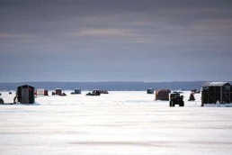
Massive. Immense. Overwhelming. Ice-fishing the bays of the Great Lakes can be an exhilarating, intimidating experience. All five Great Lakes (six, if you sneak Lake St. Clair into the mix) are vast. If fish are far offshore, it means miles of travel by quad or snowmobile—traversing cracks and heaves along the way—to get to where you think the fish are. Luckily, you can narrow down this massive expanse and fish small.
Once to a spot where the shoreline is out of sight, you might feel that you’re as close to being on the surface of the moon as you’ll ever experience. But, you face up to this odd desolation because you’ve heard that the bite’s hot with anglers pulling big ones through the ice. You crave the action. But where do you start your search for fish?
Targeting high-density zones
The biggest problem with ice-fishing any huge expanse of water is narrowing down the places where the fish could be. After all, your time on the ice is limited and you want to be drilling holes over an area with the highest density of fish.
The best way to figure out where to drop a line when ice fishing big lakes is to change your mindset and think of them as small lakes, narrowing down the many possibilities to just a few. And it’s easier than ever with modern-day electronics.
Have a plan
One thing that has not changed for me over the years is pre-planning the night before where, exactly, I plan on fishing. For example, one of the first things we instructors do during the Ice-Fishing Vacation/School held on Lake Huron’s Saginaw Bay (this year February 18 through 21, 2018), is to strategize our next day with all our attendees.
Perusing large paper maps still works to scan the lay of the underwater land and pinpoint structure likely to hold fish. But, many hard-copy maps are not detailed. Navionics mapping programs, however, have changed the way we fish. Their ultra-detailed maps come pre-loaded on SD cards—which I link with my Lowrance GPS devices. Navionics also has downloadable apps for smartphones, tablets and personal computers.
Narrow the search with Navionics
With a Navionics app running in my laptop, our large group can plan our next day’s fishing. We can fish small, right down to the longitudes and latitudes of underwater humps, cuts, points and breaklines. We then program the spots into our GPS units. With the aid of a digital projector, everyone in the group can see and understand the types of structure they will fish.
When you load Navionics maps onto your smartphone, the device also serves as a back-up GPS. If your main unit fails, you have assistance getting back to where you started. (Tip: Remember to always let others at home know where you are fishing and what time you’ll be home. Do not deviate from those plans.)
You can be among the first to get the latest info on where to go, what to use and how to use it!
Beeline
Electronic mapping also gives you the direct path to your planned spot where, upon arrival, you can set up immediately over structure. Fish small over these likely spots to hook the most fish.
It’s a real timesaver on the ice. You can be on your spot before the sun rises. This allows the environment around you to settle down. Fish then return to their natural state for prime fishing time. The GPS I use nowadays for driving to and from fishing spots is a Lowrance Hook-5 Ice Machine. It’s a portable sonar/GPS all-in-one unit. The 5-inch color screen is easy to see in both bright and dim conditions. Plus, the unit has a card reader for my Navionics SD cards.
Fish small and keep quiet to catch the most when ice-fishing.
In place
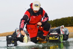
The first thing I do when I get to where I want to fish is to start up my StrikeMaster power auger and drill all the holes I’ll need in the area. Then, I walk hole to hole and check for depth, structure and fish with the Hook-5. This unit is portable and even has space for two Plano tackle totes. I’ll stash a few Rapala Jigging Raps and Northland spoons, just in case I see fish and need to change lures while hole hopping.
I find the hole I first want to drop a lure through. Then, I’ll set up my Clam portable shanty, turn on my portable heater and lower my MarCum underwater camera. My Marcum VS825SD has taught me much while on the water of the Great Lakes. Its 8-inch, flat-panel color screen has shown me how fish react to the lure. I can figure out whether I need to change styles or colors to get the fish to strike. This is another timesaver when fishing waters where travel time eats up much of the day.
Get there, see, and get back
Yes, modern electronics allow us to fish small on big water. We now have more accurate mapping and can get to spots likely to hold fish faster than ever. And, as an added safety factor, being able to get back to shore right where you left. No matter how severe the weather, today’s electronics can save the day.
Mark Martin is a tournament walleye fisherman and an instructor with the Ice-Fishing Vacation/School (icefishingvacationschool.com) which will be coming to northern Michigan’s Burt Lake and Lake Huron’s Saginaw Bay this winter. For more information, check out Mark’s web site at markmartins.net.
Did you enjoy this post?
You can be among the first to get the latest info on where to go, what to use and how to use it!