
Learn to Read Your Waters
With this winter, I’m not really certain that by the time you read this article, whether we will be drilling holes or standing on the bank for an extended open-water season. Kind of hoping for either!
This article in particular crossed my mind a few times, but due to some email questions, tackle shop talk and bank side interaction, I thought that before we head into another open-water season, the content would be appropriate and hopefully increase your success on the water.
The big question really goes something like, “I’m going to lake or pond “X”—never been there, where do I start?” Of course, follow-up questions could be, “What are you fishing for? Using artificial or live bait?” And a host of other questions that could be part of the equation of ensuring a successful outing.
But to me, the first key to success on a new location is how to read the water: what’s happening from the surface down to the bottom. Once you become proficient at it, your tackle presentations and species will all fall into place.
If you are fishing well-known bodies of water, lake maps probably exist and will often show you contour lines and often, underwater fish attractants. We used to call them “cribs” when I was growing up. Call them what you like, they can be an aid in finding fish structure. MidWest Outdoors has an awesome marked map section if you’re heading to one of the more popular bodies of water. But what if lake or pond “X” is not mapped? This is when the ability to read your water pays huge dividends.
More than one article is really needed to maximize the ability to read and cover many types of waters, but we will look at some basics and target areas I have found to be successful.
I am certainly not trying to be critical, but it is hard to watch bank anglers fishing in 15 to 20 feet of water with a ‘crawler or minnow suspended a foot or two below a bobber and wondering why they are not getting “bit.” So, really before reading your water, you need to understand some common, basic fish behavior. Again, every species can have their own book written concerning their particular traits. Here, we will just be looking at general multi-species-type behavior.
Fish are just not wandering around a body of water aimlessly for no reason. They travel, suspend, bury in the weeds, hang close to bottom, etc., with a purpose. They could simply be on the move from one seasonal location to another, such as moving shallow for the spawn, maybe to find more suitable oxygen levels or to areas that provide protection in cover. Besides the oxygen, I believe food is one the major reason fish are found in certain areas, keeping their food source in very close proximity.
So let’s get started. Remember, we are not going to get so much into species locations, but rather understanding the water you are casting into.
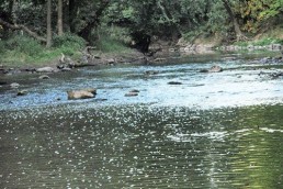
First, when you arrive at a new lake or pond, before making that first cast, assess the entire section of workable shoreline. Does the bank’s degree of pitch or angle from ground level change around the lake? Steep banks are often a good indication of deep water near shore. A gentle sloping shoreline often extends in the same manner under water, creating more of a shallow flat area. Both spots can be awesome locations, just depends on the season.
You can be among the first to get the latest info on where to go, what to use and how to use it!
As the water warms, another good read is the presence of weed cover. A shallow sloping bank and underwater flat may have weeds extending from the bank out to 30 to 40 feet, depending on water clarity. The end of the weedline is often a good indicator of a drop-off or bottom change.
Speaking of bottom changes, weeds can be an excellent indicator of not only depth changes, but of bottom makeup, such as transitions from a softer bottom such as muck, sand, or clay to a rock or rubble bottom that might be unable to support weed growth.
Bottom-type transitions are key fish-holding magnets. I fish a small lake, which was manmade years ago. There is an area where rock was dumped along about a 50-foot section of bank out into the water. Weeds grow up to this rocky area from both sides, but not in the rocky area, creating this transition from a softer bottom and weeds to a hard-rock bottom. I have never fished that spot without catching fish. Another added attraction near that rocky area is a water inlet, which leads into the next area to look for while scouting the bank.
Water inlets, whether drainage-type culverts, storm water drains or just more natural earth formed in ditches that dump in rainwater, are key locations, more so if there is a moderate to heavy drainage occurring. This water inflow can help oxygenate a lake or pond, but more importantly, wash in food such as insects, worms and ‘crawlers. Fish will line up like those waiting in line at a buffet for the next morsel of food to enter the water.
Still, scoping out the shoreline, I’ll look for wood in the water. Fallen trees, if they extend into deeper water, are always worth investigating. Trees that overhang the water often go unnoticed, besides offering shade, insects that live in these trees often fall into the water. Homemade wood piers or swimming and diving platforms are also excellent fish-holding structures. Stick-up areas where you see old trees that were once in the water can be good, but unlike some of large impoundments with flooded timber, these areas in smaller lakes usually indicate somewhat shallow water and can be productive especially in the early season.
Another shoreline attractant is large rocks in the water. Most smaller bodies of water here in this part of the state have few large natural rocks. But what you will find in many lakes and ponds is riprap or broken pieces of concrete that were dumped on the shoreline mostly to prevent shoreline erosion. These areas can attract just about all fish species.
One important thing to remember when checking out water structure is distance from the shoreline. As a bank angler, you need to concentrate your exploring and fishing from the edge of the bank out to about 40 to 50 feet offshore. Can you cast farther? Sure. But by limiting your target area, you can really pick apart your close-by structure and fish attractants much more thoroughly. Just as an example, Heidecke Lake is a rather large body of water for the bank angler to cover. But regular outings for me have proven that probably better than 95 percent of my largest fish have been taken less than 20 feet from the shore—and many fish coming just a few feet from the bank.
In closing, this is just the tip of the iceberg concerning the ability to read the water. Become efficient at it and success will follow. I once read that approximately only 10 to 15 percent of a body of water actually contains fish, and I believe it. That’s why I narrow my fishing down to target locations, such as those discussed in this article.
So this upcoming season, maybe hit the banks with a different approach. Concentrate your fishing to some new structure and target areas and learn to interpret the waters you fish. Break away from the regular fishing spots and venture down a section of bank not normally taken.
If you have any questions or comments you can reach Dan Brozowski at onthebank@att.net.

Did you enjoy this post?
You can be among the first to get the latest info on where to go, what to use and how to use it!