Raising an Angler: Reading Hydrographic Lake Maps
Map reading made easier
Learning how to read a hydrographic lake map can be challenging. It’s about more than contour lines and depths. Map reading is, in many ways, as essential as casting. This map guide will help you teach newcomers to the sport how to read hydrographic lake maps.
There are few things in this world that can get guys to put on that total face of confidence on the outside and utter confusion on the inside than a hydrographic map. Add in a GPS, and chests get pumped up and out and fingers are pointing and statements are made with confidence. This is usually followed by a quick check on a tablet to see if they were right, or worse, trying to figure out what that other guy actually said.
An essential skill
My view on map reading has proven to be a little different than most people I talk to. In my opinion, it’s more important than knowing your knots. I believe this for two reasons: First, I like to catch fish and am very impatient. Second, I have seen the importance of learning basic map skills at an early age versus later in life. It is kind of like learning a foreign language before your voice changes; it’s just easier. Not to mention in high school, the kids can’t use getting lost as an excuse for being late.
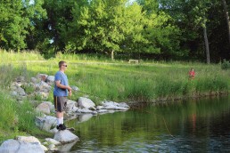
So why am I bringing up map reading in a series on raising an angler? The answer is simple. Many well-intentioned new angler fishing trips have failed miserably because of the lack of map reading skills, or worse, no map at all. This is true not only in the boat but on shore as well. It would be safe to say that a map is more important to the success of a shore fishing trip than a boat trip. If you set up on the wrong spot on shore, you may never know it without a map.
The other thing I love about maps and young anglers is the adventure it brings to a trip. When the kids get to that point where you can sit around at night and plan a trip together, look at the road map on the best way to get to the lake, and then look over the lake maps to find the best places to go and where to start, it’s a shared experience. This is about life skills that will set them apart when they grow up—you learning how to stay young while setting out on an adventure with the kids, and catching fish when you get there.
Contour maps
For those of you that know the lines, this should be a good refresher and is how I explain mapping to the young anglers I am out fishing with. For those of you that don’t know the lines, don’t be afraid; it looks harder than it really is. There are just a couple of things to learn.
First, the distance between the lines shows how steep the drop or slope of the bottom is. The closer they are together, the steeper the drop or rise is. The further apart they are, the more gradual the drop or rise is. What mappers do is connect the dots everywhere there is a curtain depth (Diagram 1). Second, where the area between lines is an average slope, don’t mistake it for being a straight line. There are all sorts of small ups and downs on the bottom between two contour lines.
The greater the area between lines on the map, the more unseen changes there can be. The tighter the lines are together, the fewer unseen changes there can be.
Some of the lines are labeled with a number; these numbers are the depth in that spot. Looking at how the numbers go up and down shows you whether it is getting deeper or shallower (Diagram 2).
You can be among the first to get the latest info on where to go, what to use and how to use it!
Finally, you will find maps with only a few lines, and others with lots of lines. This is the difference in detail, not depth. The easiest way to tell is to look at the numbered contour lines. The smaller the interval between the numbers, the more detail; the greater the interval between the numbers, the less detail (Diagram 3).
Hidden information
Understanding the stuff on the map that isn’t on the map is important. Now, that sounds confusing. Many maps just show you contours, and there are some things you need to look for to find the hidden information. But if you look at most game and fish department or natural resources websites with old school fishing maps, the information you need is right there for you to have.
Bottom type is a big deal when reading a map (Diagram 4). Mud bottom lakes are more likely to have more weeds than rock or gravel bottom types. This information lets you better guess if a long point will be covered in weeds or if it will be a gravel bar. It also helps you determine the kind of tackle you should bring. Muddier bottom lakes may be a better slip bobber and top water lakes, while gravel lakes are better for a floating jig and a minnow and spinners.
Aerial and satellite imagery are another good way to see what you will encounter at a lake or river you are considering for your trip. This is a great way to find hidden information on rivers and shallow or clear lakes (Diagram 5). Access is a big deal when you are looking at a lake to fish. Many maps don’t show access other than boat ramps and fishing piers. Looking at satellite imagery along with the map helps to figure out the access issue (Diagram 6).
The bow
There is one principle to map reading that is important when you are shore fishing. Think of every place you are standing as if you are in the bow of the boat. By knowing what is on the map, you can make the same decisions in either place. There is really no difference. Is there a place a fish should be? Is the lure/bait something that will invoke a strike? Will the lure/bait I chose reach the spot I need to catch the fish? If the answer is no to any of these questions, change the presentation and/or location until you can answer yes to these questions.
Whether you are in a boat or on shore, you need to move until you find fish and can reach them. It’s hard to hear about fishing trips that yielded no fish because of fishing in the wrong spot, with a good spot only a short distance away.
There are a ton of map options out there to use and many are free. Our favorites are maps like the ones provided by the ND Game and Fish on their website. These are also shaded so you can more easily read the contours, and they show the satellite imagery around the lake so you can make a good decision on where to fish (Diagram 7). The free Navionics app for tablets and phones is a great way to take your maps with you, and has multiple options that help you get the big picture quickly (Diagram 8). We print off maps at home and take them with us to local bait shops so that we can mark them up with information we get when buying bait.
Learning and teaching map reading is fun when you let it be. It is a little thing that makes a big difference in making a successful fishing trip “a positive outdoor experience.”
Author notes:
Geremy Olson is an avid outdoorsman, producer and public speaker, 241ink.org, whose son Peter also writes a monthly feature for MidWest Outdoors.
Did you enjoy this post?
You can be among the first to get the latest info on where to go, what to use and how to use it!