The Best Tool in Catfishing
Brad Durick finds live mapping to be an invaluable tool in catfishing. Learn the most effective ways to use it to find more catfish.
Technology is moving forward at breakneck speed. Yet going back a few years, one technology, in my mind, has more useful importance than any other: The ability to make live maps.
Live mapping is built into most new depth finders. It allows you to make your own maps of the bodies of water you fish. Some can even overlay what type of bottoms substrate or weeds may be present.
Live sonar was never meant to map entire lakes or rivers, but rather map the spot-on-the-spot to fill in the gaps that map chips may have missed. It turns out that, with proper time and planning, this technology can make previously unmapped waters fully mapped, and take much of the guesswork out of finding honey holes.
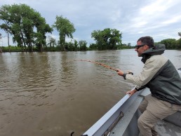
I use AutoChart Live on a Humminbird Helix 10. I have also added a Zero Lines card to give me virtually unlimited mapping space. Being a full-time guide who is on the water every day, I took the time to map all my guiding waters—about 60 river miles. Our river (Upper Red River, No. Dak.) is a little over 100 yards wide, meaning that to get a great quality map, I need to do five passes of the river. I map at about 8 miles per hour, going parallel to the river. I start on one side of the river and go approximately a mile before turning and going back along the other bank. When I reach the end, I turn back, moving more toward the middle of the river, using the provided line to match up with the previous pass. I complete the turn, then drive right down the middle of the river to tie both sections together. I should note that in my case, I only map when the river is 18 to 19 feet deep on the gauge.
Each section of river mapped takes about 40 minutes to complete. Once a section is done, I stop the AutoChart Live, then restart it. This saves the file and starts a new one. There are two reasons for this: 1) If I make a mistake, I can delete the file and start over; and 2) If I have to stop and go home for some reason, I have a fresh spot to start the next time, because the map is completed to that point.
Another way to map that takes much less time is to map out just the areas you wish to fish. This will give you the same map in those areas, and help you find the breaklines and holes within your favorite areas to fish.
How to use the map
In a river that has been properly mapped, all the breaklines and holes will be shown in great detail. Our job as anglers is to identify the patterns that produce the best fish and repeat. Maps can lead the way, and over time, with experience and dropping waypoints on spots, these patterns can literally become milk routes.
You can be among the first to get the latest info on where to go, what to use and how to use it!
If you have established that holes are where the fish are, mapping software (Auto Chart Live, at least) can be color coded with the range setting. I have mine set up so very shallow/dangerous areas are displayed in brown, flats are yellow and holes are blue. The darker the blue, the deeper the hole.
If I find catfish in holes, I will take note of the color (depth) of that hole and try to find another one that color. If you find fish in that hole, then the pattern has been established, and it becomes hole-hopping to whatever that color may be that day. Using the colors saves time because you are not driving around looking for a specific depth range; the map already provides it for you.
Taking this a step further, most of the time, catfish are working a certain breakline, whether it be the on current side or the off current side of the hole. The maps will show you precisely where that current break is. Your job from there is to identify what the on and off current seams are and which one the catfish prefer.
Not everyone has the time to map an entire river, so one good way to utilize mapping time is to map out the high points, such as bends in the river or areas where you have caught fish before. This gives you a broken map, but it can be built upon over time as well.
Most of the time, anglers fish bends because they are traditional holding spots for fish. Use it is the same as above, although you may be missing some of the straightaway or transitional areas. It is a good start to the process and can still provide more consistent success.
Live, precision mapping is the greatest technological advance in catfishing that I have found so far. Whether you use Humminbird, Lowrance or Garmin, they all have it in some variation. It is a technology that, if used properly, will make you a much more effective catfish angler.
Keep up with the latest in fishing gear and technology with information from industry leaders found in every issue of MidWest Outdoors, available by subscribing on our website.
MWO
SHARE THIS POST
Did you enjoy this post?
You can be among the first to get the latest info on where to go, what to use and how to use it!