How Do-it-Yourselfers can Experience Lake Erie’s Most Reliable Ice Fishing
With La Nina beginning to take form in the Pacific Ocean, some weather forecasters are promising a cooler winter for 2020-2021, which is just fine with John Hageman.
To say that the rank-and-file ice fishermen in Western Lake Erie are anxious for a “real winter” would be an understatement. A 1-day ice season would be an improvement from last year, and any fishable ice beyond a few days (other than in the Bass Islands) would be an improvement from 2 years ago.
Scores of big fish remain from the massive 2003 year-class hatch, which can still provide anglers with their personal best fish.
The Lake Erie Islands
The Bass Islands chain is composed of a ridge of limestone called the Put-in-Bay Dolomite that extends north from Catawba Point, Ohio to Stony Point, Ontario. While most are uninhabited, South Bass Island is home to the village of Put-in-Bay, the most populous and developed community.
There, winter amenities such as taxi service, a grocery store, beverage center, gas station, general hardware store, one or two restaurants and lodging options are available.
Generally, the first place that gets fishable ice is Stone’s Cove on the west side of South Bass Island. As drifting ice piles up against it or new ice forms outward from its coastline, an ice field grows out toward Green Island.
The next place that ice floes jam up is between South Bass and Rattlesnake Island. The craggy coves and funnels between the islands catch these floes after they are formed in the shallower western end of the lake, which chills soonest.
The bigger sheets become wedged in between the islands like pieces of a jigsaw puzzle as they drift eastward in the prevailing winds and ever-present current. If frigid temperatures follow, the open water in between the pieces cement everything in place with new ice.
Some years, these two places, and some shallow bays and harbors, are the only places to ice fish on all of western Lake Erie.
Because of Put-in-Bay having the infrastructure combined with often being the “only game in town,” dozens of ice guides have set up camp there for generations. However, in recent years, there are fewer guides operating and with fewer rental huts (shanties).
It would be a shame to waste a rare real winter—if we get it—by not fishing, just because guides are scarcer.
So, as a former Put-in-Bay ice guide who still enjoys seeing people having fun on the ice, the following will provide DIY ice anglers with enough information to get started fishing on Erie’s safest ice.
Getting to Put-in-Bay
Since there are no bridges to the islands, extra effort and expense is required for ice fishermen to get to Put-in-Bay during winter.
The only commercial transportation to the islands is by small aircraft. The most efficient airport to use if traveling by auto is the Erie-Ottawa Regional Airport at 3255 East State Street, Port Clinton, Ohio.
Two local companies provide daily trips, weather permitting, between Port Clinton and the islands including South Bass, Middle Bass, North Bass, Kelleys and Rattlesnake (private).
Griffing Flying Service is a family-run operation that owns a fleet of several planes and transports most of the passengers, island-bound freight, and the U.S. Mail. Flights can be arranged by calling 419/734-5400.
Island Air Taxi also runs trips to the same locations and can be contacted at 419/573-2960. Keep in mind that with both companies, the sizes of the planes preclude the option for anglers to “bring the kitchen sink.”
Instead, stick to the bare necessities—fishing gear, bait and snacks—plus obviously more luggage if staying overnight. Rigid portable shanties or sleds will generally not fit, and combustibles/flammables cannot be transported, which eliminates propane heaters and all but an electric or manual auger.
You can be among the first to get the latest info on where to go, what to use and how to use it!
Soft-sided coolers are better than hard plastic or metal ones. Buckets for shiners and fish finders are commonly used, but while due care is practiced, rod cases are safer than buckets, since luggage is stacked to fill in all of the available cargo space. Many carry their fish catches back in a burlap sack or similar seed bag.
Getting to the ice and the island
On South Bass, there is taxi service operating during the winter. Even though the island is only 3 miles long from end to end, taxis are still helpful for getting from the airport to the ice ramps and for those staying overnight, traveling back and forth between their lodging facility, restaurant and ice ramp.
Accessing the ice
There are four public places to enter the ice: Downtown, South Bass Island State Park, the “New Ramp” and the “Old Ramp.”
The public boat/ice ramp downtown will get you on Put-in-Bay Harbor’s ice, where lush underwater vegetation holds good numbers of yellow perch in a range of sizes; other panfish such as pumpkinseed sunfish, bluegills and white perch; some largemouth bass; and other surprise species that I have seen on my underwater camera, such as young wandering muskies, smelt and even a carp with a hitchhiking sea lamprey.
Water depths in the main harbor average about 13 feet. There are shallower areas closer to the marinas. To the east, outside the weed beds and the lee provided by Gibraltar Island, it drops to over 25 feet, and then to over 40 feet in the open lake channel.
Warning—the deep-water channel is never considered suitable for ice fishing due to the funneled, swift currents keeping the ice thickness unpredictable. Also, the west entrance to the harbor is guarded by Peach Point Shoal and other gravel bars, which rise close to the surface and have swallowed dozens of recreational vehicles passing over them. Stay in the main harbor between South Bass and Gibraltar Islands!
The South Bass Island State Park ramp (for walleyes) can be used to fish in between South Bass and Green Island. This ice is typically the first to become ready as the west-facing cove catches the first floes that drift in with the prevailing currents.
When using this ramp, the safety boundaries that should never be crossed are beyond the cracks that form from the southeast corner of Green Island to the South Bass Island Lighthouse, and between the north side of Green Island to the Rattlesnake Island “Rattles.”
Warning! Ice outside of those “lines in the sand” is considered always unstable and often disconnects from the rest of the more stable ice sheet, with little notice, on the first warm day or with an east wind.
The New Ramp (for walleyes, yellow perch, white bass, white perch, etc.) on the West Shore of South Bass was specifically built to be used just for ice fishing access. It is the most heavily used ramp to fish the main ice sheet between South Bass and Rattlesnake Island, which provides an area of a couple of square miles to roam in a typical winter.
Plenty of fish are caught within brief walking distance of this ramp, in the shadow of the M/V Benson Ford, a former Ford Motor Company freighter, now perched upon the West Shore cliffs.
Many anglers follow the main trail leading to the south side of Rattlesnake Island but stop partway to find fish out of the traffic. While Rattlesnake Island tends to be a favored location to fish near, fish can be found elsewhere along the way, which can save time and miles of walking the full two miles to the Rattles.
Roam with caution around: 1) Victory Point, which juts out from South Bass Island beyond the Benson Ford to the west. It is responsible for occasionally dunking snowmobile/ATV riders rounding this underwater shoal too close while returning from Green Island, or on portions of the point that erodes ahead of the rest of the surrounding ice shelf due to currents; and 2) If you are tempted to fish the north side of Rattlesnake, be reminded about the unstable ice beyond the Rattles on the west end, and be aware that there is a shoal extending out from the southeast tip of Rattlesnake Island that keeps the ice thinner all winter from the deflected currents. Many rigs have fallen through there, too, cutting too close around the point.
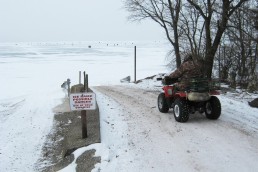
The Old Ramp (for walleyes, yellow perch, white bass, white perch, lake whitefish) is a single paved lane threaded between two houses that is used as an entrance/exit for the ice road connecting Middle Bass and Rattlesnake Island residents to South Bass Island. It also provides local ice fishermen a slightly shorter 1.9-mile route to Rattlesnake Island.
Warning! The ice near this ramp is more prone to rapid deterioration from the erosion of ice that expands outward from Peach Point, the shoal (which, as mentioned above) defines the western entrance to Put-in-Bay Harbor.
The Lake Erie Shores & Island Welcome Center can assist with the logistics of setting up a trip by calling their office at 800-441-1271 or 419-734- 4386.
Want to try a new destination for fishing this year? Get inspired by articles found in the winter issues of MidWest Outdoors, available by subscribing on our website.
MWO
SHARE THIS POST
Did you enjoy this post?
You can be among the first to get the latest info on where to go, what to use and how to use it!