Lake Maps 101
Lake maps are important tools to help you when you are looking for places to fish. If you have never looked at a lake map, however, it can be overwhelming because of the sheer volume of information on it.
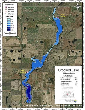
One of the first and most obvious things you will see on a map is a network of lines extending all over the map. These lines have a few parts to them. The first thing that the lines show is the depth contour. Alongside the lines, there is a number that tells you the depth of that contour. All of the area extending along that line is pretty much the same depth.
The next part about the lines is the space between the lines. The space between the lines shows the change in depth. It also shows the change in the slope of the bottom of the lake, meaning it shows how fast a change in depth occurs. When the lines have a larger gap between them, that means that the change in the slope is slower. When there is a smaller gap between the lines, that means that the change in the slope is steeper.
One misunderstanding that many people make is that they assume that there is a constant slope between contour lines. Contour lines and the space between them represents only an average. In addition, contour lines don’t show the actual makeup of the bottom—for example, holes and rock piles. In effect, contour lines are starting points on where to look.
The legend is a very important piece on a map. The map legend shows you the meaning of each symbol on the map.
Along with the legend, you will find the map scale. The map scale is another very important part of a map. It allows you to determine the distance from point A to point B. You can typically find the scale in one corner of the map. Most of the time, the scale will indicate different measurements—like feet or miles—so you can choose if you are going to proceed across a large or a small distance.
Electronic overlays
There are a lot of different styles of maps. If you are viewing a map electronically, such as online or on your GPS, you are often able to change overlays on the map. These overlays are typically adjustable, may be set to indicate shallow water, a depth range of particular interest, or other preferences.
The Navionics website (navionics.com) is a great place to look at a map online because of the detail they provide. You can switch from a standard map to a sonar map, which is a map that is much more specific in detail.
Another good place to look for lake map info is with your state game and fish department. They typically have a lot of maps available online or printed on paper. With all the new technology out there today, anglers tend to overlook the good old paper maps. Admittedly, These maps are not as accurate as newer electronic versions for looking at contours. However, they are typically great for telling you what the makeup of the bottom is.
You can be among the first to get the latest info on where to go, what to use and how to use it!
Structures to spot
Maps are not only important for looking at and getting oriented to a body of water, they are also very helpful for finding good underwater structures to fish. As mentioned before, maps show changes in depth and the depth contours of a body of water. The lines on a map can also help you identify key fishing spots, like points or sunken islands that tend to attract and hold gamefish.
An underwater point can be easily spotted on a map. It is a long spot that gets gradually deeper on three sides the farther from shore it gets. A point typically starts at the shoreline, but don’t overlook a point coming off of a sunken island. They can either have a slow and steady decline (taper), or a more aggressive decline into the water, with sharp drop offs and a fast depth change on two sides.
Here in the Dakotas, where our large reservoirs are quite windswept, wind triggers wave action and currents that trigger walleyes into feeding. Identifying windswept points on a windy day can improve your productivity. Fish the points on the windswept side of the lake, looking on the upwind and downwind sides of each point to see where the fish are holding.
Sunken islands are like points in the fact that they are easy to identify on a map. Basically, they are just shallow spots in the lake with deeper water all around them, unattached to shore. Sunken islands can be almost any size. I have fished some that are the better part of a half-mile across, and some that are only a few hundred square feet.
What matters most is where the fish are. We like looking for perch during the day on the tops of sunken islands; many of those same spots will bring in walleyes at night. When fishing a sunken island, don’t forget to fish all around it, looking for different bottom types that will hold fish.
Holes or bowls are low spots on the bottom. They look similar to sunken islands but they go the other way, sinking rather than rising. These spots hold fish because they are resting and feeding places.
Holes are smaller than bowls, but they are the same thing. Bowls are just bigger in angling parlance.
Saddles are a structure that you often see when you find a group of sunken islands close together. A saddle is simply a small valley in between two sunken islands, or between the tip of a point and a nearby sunken island. Again, they can vary in size, as they connect two sunken islands.
Saddles are areas that funnel and concentrate fish through a smaller spot between them. These spots will bring fish to you when they are on the move from one hole to another.
Channels are just trenches and typically occur in nature. Examples of channels are streams and rivers. Channels can also be manmade, like a water intake, for instance. They typically have steep edges.
The fish using channels don’t always do what you think they do. Most of the time, the fish will be higher up towards the top edges, or suspended over a channel, rather than be down low.
By knowing and understanding map basics, you are able to expand your knowledge and learn the more complex pieces of the fish-location puzzle. The important thing about maps is the more you study, the more you will learn. The more you learn, the more fish you will catch.

Did you enjoy this post?
You can be among the first to get the latest info on where to go, what to use and how to use it!