New Indiana Lake Map Updates Will Help Anglers
SHARE THIS POST
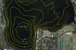
Lake contour maps have been one of the most valuable tools fishermen can use to find productive areas. The topographic maps can show you instantly where the big flats lie, where a lake bottom plunges into the abyss and where fish-holding structures like underwater points and submerged islands are.
Gamefish use the bottom contours as highways to and from feeding or comfort areas. Often, they will school on an irregular feature such as a point, an inside turn of a drop-off or on offshore humps. If you have knowledge of the seasonal patterns of each species, map study can lead you to those productive areas.
Both Indiana and Michigan provide free maps of public lakes online that you can access and print off as many copies as you want. Many of those lakes have been added to modern day fish finder units that offer mapping and GPS capabilities.
However, a historic problem with DNR maps is that many are outdated. Many of the northern Indiana and southern Michigan inland lakes were mapped 60 years ago. These are now inaccurate due to erosion, sedimentation and man-made changes that have occurred over the decades.
Now, the Indiana Fisheries Research Division has been aggressively remapping northern lakes and posting them on the DNR website. Those maps haven’t been made available to the electronic mapping companies for use in fish finders. However, you can still pull up the map on your smartphone or device while on the water or print them out from a home computer.
Are you enjoying this post?
You can be among the first to get the latest info on where to go, what to use and how to use it!
The methodology is pretty interesting: When fisheries personnel visit a lake to do studies, they utilize Lowrance HD GPS units on state boats to conduct bathymetric surveys and record lake-bottom depth readings, vegetation content and also bottom hardness. That information is then saved to an SD card and uploaded into an office computer and shipped to a private company that prepares the maps. Several of those newer maps can be found on the DNR website in.gov/dnr/fishwild/5759.htm. The ones that have been updated are designated as a “bathymetry map,” and each one of those is dated so you know which was been updated most recently.
Northern Fisheries Supervisor Jeremy Price said his crews would be working with newer technology this year, which should make the maps even better. For example, the contour lines will be sharper and the varying degrees of depths will be color-shaded (blue) so that shallower waters will stand out more prominently than the deeper waters.
The bathymetric maps will provide the DNR with documentation of where there is vegetation and hard bottoms, but the public maps will only show depths.
The DNR plans to remap 20 lakes a year. Among the newest lakes to be added to the DNR site in a few weeks include Worster Lake in St. Joseph County, Hoffman, Pike and Little Pike lakes in Kosciusko County, Hog Lake in LaPorte County and Cass Lake in LaGrange County.
MWO
SHARE THIS POST
Did you enjoy this post?
You can be among the first to get the latest info on where to go, what to use and how to use it!
Louie Stout
Louie Stout is a Hall of Fame journalist and longtime Bassmaster Senior Writer who has covered Indiana and Michigan outdoors for more than 40 years. He’s co-authored three books with Kevin VanDam and is the outdoors columnist for the South Bend Tribune.


