Making Michigan Fishing and Public Access Better
The Northern Lake Huron Management Unit (NLHMU) encompasses all of the waters that make up the watersheds that drain into the northern portion of Lake Huron, from Sault Ste. Marie south to Oscoda. This unit includes all or portions of the following counties: Chippewa, Mackinac, Cheboygan, Emmet, Presque Isle, Charlevoix, Cheboygan, Otsego, Montmorency, Alpena, Alcona, Oscoda, Crawford, Roscommon, Ogemaw, and Iosco counties. Fisheries staff working in this unit cover a diverse array of inland waters and Lake Huron ports. This diversity includes famous trout rivers, a large number of small inland lakes, some of Michigan’s largest inland lakes, popular waters where lake sturgeon roam, and key Lake Huron fishing ports.
The NLHMU is continually working towards making fishing better in Michigan and helping to improve public access to the state’s world-class fishery resources. For instance, the unit has been fortunate in Northern Lake Huron to have been involved in some land acquisitions that will let anglers explore some new waters! Northern Lake Huron Management Unit staff have been diligent in increasing fishing opportunity and better access to this areas world-class fisheries. They have also been fortunate to have a number of parcels or access sites acquired or funded for improvement in recent years. Some of them include the following: Storey Lake acquisition – 2100 acres (plus) including Storey Lake and Stewart Creek (trout stream). Walled Lake acquisition – warmwater fishery, quality lake regulations, with a mile of frontage on the Upper Black River. North Branch Au Sable, Lovells Township access. A Michigan Natural Resources Trust Fund (MNRTF) grant was recently awarded to Lovells Township for a safe, legal access to the North Branch. City of Sault Ste. Marie MNRTF grant – will restore safe shoreline fishing access to the St. Mary’s River near Cloverland Powerplant. Black Lake Marina – Black Lake. Burt Lake State Park access site – increased capacity. Maghielse Tract acquisition – 1,000-acre (plus), along the Au Sable River near Grayling. Guimond Tract access site – 52 acres, 1400 feet of frontage on West Branch Big Creek near Lovells. Rattlesnake Creek /East Branch Black River.
In addition, the NLHMU is responsible for several of the dams located within the unit. These are the dams that Fisheries Division provided the impetus for initial construction and is also responsible for annual maintenance. Additionally, the NLHMU funds dam safety inspections every 3-5 years which are done by a certified engineer. These managed dams are: Big Creek Impoundment, Crawford County; Cornwall Dam, Cheboygan County; Foch Lake Dam, Montmorency County; James Farm Walleye Rearing Pond Dam, Alpena County; Roberts Lake Dam, Cheboygan County, and Tomahawk Flooding Dam, Presque Isle County.
There has been plenty of action on the dam management front in the past two years. Notice that there are only six dams on this list. In 2018 there were seven, and at that time the list included the Trout Brook Pond Dam in Chippewa County. In cooperation with Lake Superior State University, the NLHMU initiated a study to determine the amount of recreational effort the impoundment generated. It was determined that the small amount of effort expended on the pond did not justify the cost of maintaining it, or the impounding of the headwaters of a designated trout stream. With avid support from DNR Parks and Recreation Division, and the United States Forest Service Hiawatha National Forest, the dam was removed, restoring Trout Brook Creek to a free-flowing brook trout stream.
The dam at Cornwall Flooding in the Pigeon River Country State Forest maintains water levels and is part of the Shore-to-Shore equestrian trail but it is aging and identified in need of major repair. DNR and Huron Pines has also received some funding from the DNR Dam Management Grant Program ($50,000) and a one-time allocation of state funds ($360,725) to repair the entire structure. This will include removal or capping of the old riser structure, removal and replacement of the pipe outlet, and rebuilding of the entire levee that supports the structure. DNR Fisheries Division owns the dam and has it professionally inspected every three years.
To preserve the unique, valuable recreation opportunities that Cornwall Flooding provides, the DNR has partnered with Huron Pines to renovate the dam. The project will: 1) protect the fisheries and wildlife of Cornwall Flooding, 2) maintain recreational uses including fishing, equestrian trails, hiking, wildlife viewing and non-gas boating/paddling, and 3) restore the aging dam infrastructure to enhance dam safety and to improve long-term maintenance operations. They are currently working with engineers to design an appropriate structure. The work was previously scheduled to start in 2020, but this may be postponed to 2021 to account for financial or contractor logistics.
You can be among the first to get the latest info on where to go, what to use and how to use it!
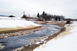
On another dam note, the Maple River near Pellston is now flowing freely. The Maple River Dam was a 1200-foot long earthen embankment about 15 feet high, creating 42-acre Lake Kathleen. The East Branch Maple River and West Branch Maple River each flowed into the impoundment. The mainstem Maple River then flows approximately 7 miles until it empties into Burt Lake. The Maple River Dam was originally built in 1884, and served as a hydroelectric dam from the early 1900s until 1951, when it failed and washed out the road below it, Woodland Road. The dam was rebuilt in 1967 and the impoundment has been in private ownership since then. The dam removal in 2018 removed the sill and spillway of the dam, restoring a more natural, riverine channel.
Fisheries Division and CRA worked with the previous and current landowners for a number of years to address concerns about the dam. Personnel from Northern Lake Huron Management Unit and the Habitat Management Unit first met onsite in October of 2002 to discuss options for the future management of the aging structure. In late 2003, CRA sought funding to look at management options as well. The owner of the dam at that time, Paxson Offield, was very supportive of conservation and wanted to do what was right for the river. Mr. Offield passed away in 2015, but the new owner, Rick Holton, has carried on that stewardship ethic.
CRA compiled a team to work with Mr. Offield, then Mr. Holton, on removal of the dam. There were a number of complexities associated with this barrier, however, that needed to be addressed: The Hungerford’s Crawling Water Beetle, an endangered aquatic insect, was known to be in the watershed; the Michigan Monkey Flower, a threatened plant, grew on the earthen embankment; and the dam was a barrier for sea lamprey migration. An Environmental Assessment (EA) was written to address these and other concerns.
Removal of Lake Kathleen was the final piece of CRA’s ambitious “Free Span the Maple” initiative, which sought to remove all barriers in the watershed, including undersized culverts. The final phase of this project included the removal of Maple River Dam, as well as the replacement of the road just downstream and a small two-track road over the East Branch Maple River. Fisheries Division has been involved in the initiative by serving as advisors for the project, as well providing funding through the Aquatic Habitat Grant program. Between 2004 and 2017, Fisheries Division contributed $579,168 in funding to the Free Span the Maple River Connectivity Initiative. The bulk of this funding was from 2016, when they awarded $430,168 in AHG funding to the final phase of the project, including dam removal and road stream crossing replacements.
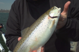
Removal of the Maple River Dam will continue to yield benefits such as cooler water downstream for trout. A Fisheries Division temperature study of the watershed found that the dam raised the average July water temperature downstream by 5.4°F, changing the stream’s classification to being marginal for trout. Also, there is now watershed connectivity. The dam had fragmented this stream, and its removal reconnects the system. This new connectivity allows for the natural transport of nutrients, sediment and wood that can provide habitat. Better fish passage has improved with the removal of the dam. Species such as brown trout and rainbow trout from Burt Lake will now be able to use the Maple and its tributaries seasonally for spawning and nursery habitat.

Did you enjoy this post?
You can be among the first to get the latest info on where to go, what to use and how to use it!